The K2 Base Camp Trek Itinerary is one of the most important things to understand before planning your adventure into Pakistan’s spectacular Karakoram Mountains. A well-designed itinerary doesn’t simply take you from one campsite to another—it carefully balances daily trekking distances, altitude gain, acclimatization, and rest to maximize your chances of reaching K2 Base Camp (5,150 m / 16,896 ft) safely and successfully.
Unlike many mountain treks around the world, the K2 Base Camp Trek takes you through one of the most remote wilderness areas on Earth. From the rugged villages of Baltistan to the vast Baltoro Glacier and the legendary Concordia, every day of the journey offers breathtaking scenery and a new challenge. You’ll hike beneath some of the world’s highest peaks, including K2 (8,611 m), Broad Peak (8,051 m), Gasherbrum I (8,080 m), Gasherbrum II (8,035 m), Masherbrum (7,821 m), and the iconic Trango Towers, making this one of the greatest trekking experiences anywhere in the world.
Following a carefully planned K2 Base Camp Trek Itinerary is essential because the route climbs gradually from approximately 3,000 meters in Askole to over 5,100 meters at K2 Base Camp. This slow ascent allows your body to acclimatize naturally to the decreasing oxygen levels, reducing the risk of Acute Mountain Sickness (AMS) and making the trek significantly safer.
A typical itinerary lasts 18 to 21 days, depending on the operator and weather conditions. Our 21-day K2 Base Camp trek begins with your arrival in Islamabad, followed by a scenic flight or drive to Skardu, the gateway to the Karakoram. From Skardu, a thrilling jeep journey takes you to Askole, the last permanent village before entering the wilderness. Over the following days, you’ll trek through Jhula, Paiyu, Urdukas, Goro II, and Concordia before finally reaching the legendary K2 Base Camp.
Each campsite along the route has been carefully chosen to provide reasonable walking distances, safe camping locations, reliable water sources, and effective altitude acclimatization. Experienced trekking companies also include a rest day at Paiyu, allowing your body to adjust before beginning the demanding glacier section across the Baltoro Glacier.
One of the highlights of this K2 Base Camp Trek Itinerary is the arrival at Concordia, often described as the “Throne Room of the Mountain Gods.” Surrounded by four of the world’s 8,000-meter peaks, Concordia offers one of the most spectacular mountain panoramas anywhere on Earth. From here, trekkers continue toward Broad Peak Base Camp before reaching the iconic K2 Base Camp, where they stand beneath the world’s second-highest mountain.
Although reaching K2 Base Camp is the primary goal, the return journey is equally rewarding. Walking back along the Baltoro Glacier allows trekkers to appreciate the scenery from a completely different perspective, often revealing views that were missed on the ascent.
This K2 Base Camp Trek Itinerary is designed for trekkers with good physical fitness and a sense of adventure. It requires no technical climbing skills, but it does demand endurance, patience, and proper preparation. Daily hikes range from 5 to 10 hours, often across rocky trails, glacier moraine, and uneven terrain.
Throughout this guide, we’ll explain every day of the trek in detail, including:
Daily walking distances.
Estimated trekking hours.
Altitude gain and elevation.
Camp locations.
Terrain conditions.
Major mountain highlights.
Accommodation and meals.
Acclimatization strategy.
Practical trekking tips.
What to expect each day.
Whether you’re planning your first expedition to the Karakoram or comparing different trekking companies, this complete K2 Base Camp Trek Itinerary will help you understand exactly what to expect from one of the world’s most iconic high-altitude adventures.
Before beginning the detailed day-by-day guide, it’s helpful to understand the overall structure of the K2 Base Camp Trek Itinerary. Knowing the total duration, trekking distance, highest altitude, and daily expectations allows you to prepare physically and mentally for the journey ahead.
Unlike shorter trekking routes, the K2 Base Camp Trek is a true expedition. The itinerary is carefully designed to balance long hiking days with proper acclimatization, giving trekkers the best possible chance of safely reaching K2 Base Camp while enjoying the incredible scenery of the Karakoram.
Below is an overview of the key facts about the itinerary.
Trip Duration
The standard K2 Base Camp Trek Itinerary typically lasts 14 to 16 days, depending on weather conditions, transportation schedules, and the trekking company you choose.
A well-planned itinerary generally includes:
Arrival in Islamabad.
Flight or drive to Skardu.
Jeep transfer to Askole.
Eight to ten days of trekking.
Return journey to Skardu.
One or two buffer days for weather delays.
Some operators also offer extended itineraries that include Gondogoro La Pass, adding several extra days and significantly increasing the trek’s difficulty.
Starting Point
The trekking portion of the K2 Base Camp Trek Itinerary officially begins in Askole, the final permanent village in the Shigar Valley.
Located at approximately 3,040 meters (9,974 feet) above sea level, Askole serves as the gateway to the Baltoro Glacier and the greater Karakoram wilderness.
Before reaching Askole, trekkers usually:
Arrive in Islamabad.
Travel to Skardu by flight or road.
Spend a night in Skardu.
Drive approximately 6–8 hours by jeep to Askole.
Askole is also where porters, support staff, and expedition supplies are organized before entering the mountains.
Ending Point
The K2 Base Camp Trek Itinerary follows an out-and-back route.
After visiting K2 Base Camp, trekkers retrace their steps through:
Concordia.
Goro II.
Urdukas or Khoburtse.
Paiyu.
Jhula.
Askole.
From Askole, travelers return by jeep to Skardu before continuing to Islamabad.
This return route offers fresh perspectives of the Baltoro Glacier and surrounding peaks, making the descent just as memorable as the ascent.
Maximum Altitude
The highest point reached on the standard K2 Base Camp Trek Itinerary is:
K2 Base Camp — 5,150 meters (16,896 feet)
At this altitude, oxygen levels are approximately 50% lower than at sea level, making acclimatization one of the most important aspects of the itinerary.
Trekkers typically spend only a short time at K2 Base Camp before returning to lower altitude for the night, reducing the risk of altitude-related illness.
Total Trekking Distance
The complete K2 Base Camp Trek Itinerary covers approximately:
180–200 kilometers (112–124 miles) round trip.
Daily trekking distances generally range between:
10–20 kilometers (6–12 miles)
The exact distance depends on campsite locations and minor route variations caused by glacier conditions.
Difficulty Level
The K2 Base Camp Trek is widely considered a challenging to very challenging high-altitude trek.
Although no technical climbing experience is required, trekkers should expect:
Long hiking days.
Rocky and uneven terrain.
Glacier crossings.
High altitude.
Cold temperatures.
Remote camping conditions.
Good physical fitness, mental resilience, and adequate preparation are essential for completing the trek safely and comfortably.
Best Time
The Best Time to follow the K2 Base Camp Trek Itinerary is during the official trekking season from June to September.
However, the most favorable months are:
July – Excellent weather, comfortable temperatures, and ideal conditions for first-time trekkers.
August – The most stable weather, outstanding mountain views, and the highest success rates.
June – Fewer crowds, fresh snow on surrounding peaks, and spectacular photography opportunities.
September – Quiet trails, crystal-clear skies, and beautiful autumn scenery.
Choosing the right season plays a major role in the success and enjoyment of your expedition.
Route Map Overview
Before beginning the K2 Base Camp Trek Itinerary, it’s helpful to understand the complete route from Islamabad to K2 Base Camp. The trek follows a well-established path through the spectacular Karakoram Mountains, passing remote villages, vast glaciers, and some of the highest peaks on Earth.
The journey starts in Pakistan’s capital city and gradually enters the wilderness of Baltistan before reaching the legendary Baltoro Glacier. Along the way, trekkers experience changing landscapes, increasing altitude, and breathtaking mountain scenery.
Unlike many trekking routes that form a loop, the K2 Base Camp Trek Itinerary follows an out-and-back route. After reaching K2 Base Camp, trekkers return along the same trail, offering a completely different perspective of the mountains and glacier.
Below is an overview of every major location along the route.
Islamabad
Every K2 Base Camp Trek Itinerary begins in Islamabad, the capital city of Pakistan. This is where most international trekkers arrive after landing at Islamabad International Airport.
Upon arrival, trekkers typically spend one night in the city to recover from international travel, organize equipment, and attend a pre-trek briefing with their trekking company. During this time, guides review the itinerary, distribute permits, inspect trekking gear, and answer any final questions before the expedition begins.
Islamabad also offers excellent opportunities to purchase any last-minute trekking equipment, exchange currency, or explore attractions such as Faisal Mosque and the Margalla Hills.
Although Islamabad is far from the Karakoram Mountains, it serves as the official starting point for nearly every K2 Base Camp Trek Itinerary.
Skardu
From Islamabad, trekkers travel to Skardu, the gateway to the Karakoram Mountains. Depending on weather conditions, this journey is completed either by a spectacular one-hour flight or by road via the famous Karakoram Highway.
Located at approximately 2,230 meters (7,316 feet), Skardu is one of Pakistan’s most important mountaineering towns and the final major city before entering the wilderness.
Most trekking companies spend one or two nights here to:
Complete permit formalities.
Purchase fresh food supplies.
Organize porters.
Inspect camping equipment.
Allow trekkers to begin acclimatizing.
Skardu is surrounded by stunning scenery, including the Indus River, Satpara Lake, Shangrila Resort, and ancient forts. It is also the last place where trekkers enjoy modern facilities such as hotels, restaurants, banks, ATMs, pharmacies, and reliable mobile networks.
Askole
The next stage of the K2 Base Camp Trek Itinerary is the exciting jeep drive from Skardu to Askole, the last permanent village before entering the Karakoram wilderness.
The drive takes approximately 6 to 8 hours, passing dramatic mountain roads, river valleys, suspension bridges, and remote Balti settlements.
Situated at around 3,040 meters (9,974 feet), Askole marks the official starting point of the trekking expedition.
Here, trekkers meet their porter teams, final supplies are distributed, and camping equipment is loaded before the journey into the mountains begins.
Once you leave Askole, there are no roads, hotels, or permanent villages until you return several days later.
Jhula
The first trekking destination is Jhula, located along the Braldu River. This relatively easy first day allows trekkers to adjust gradually to carrying a backpack while enjoying impressive views of rugged cliffs and flowing glacial rivers.
The trail follows dusty paths and rocky terrain, with several small stream crossings along the way.
Jhula serves as the first campsite of the expedition, providing:
Dining tent
Kitchen tent
Sleeping tents
Fresh glacier water
Beautiful mountain scenery
Although the scenery is impressive, the real high-mountain environment begins in the following days.
Paiyu
Paiyu is one of the most important camps on the entire K2 Base Camp Trek Itinerary.
Located at approximately 3,450 meters (11,320 feet), Paiyu is the last campsite with scattered trees before entering the glacier environment.
Most trekking itineraries include an important rest and acclimatization day here. This extra day allows trekkers to adapt to the increasing altitude before beginning the demanding Baltoro Glacier section.
Paiyu is also famous for offering the first spectacular views of:
Trango Towers
Cathedral Peaks
Paiyu Peak
Its grassy campsite, fresh water, and relatively comfortable surroundings make it one of the most pleasant camps of the expedition.
Urdukas
Leaving Paiyu behind, trekkers step onto the magnificent Baltoro Glacier, one of the world’s longest non-polar glaciers.
After several hours of trekking across glacier moraine, the route reaches Urdukas, located at approximately 4,050 meters (13,287 feet).
Unlike the surrounding glacier camps, Urdukas sits on a rocky terrace overlooking the Baltoro Glacier, offering one of the finest panoramic viewpoints of the entire trek.
From Urdukas, trekkers enjoy incredible views of:
Trango Towers
Cathedral Peak
Uli Biaho Towers
Baltoro Glacier
Many trekkers consider Urdukas one of the most scenic campsites on the expedition.
Goro II
Continuing deeper into the Karakoram, the trail reaches Goro II, one of the highest overnight camps on the trek.
Situated at approximately 4,300 meters (14,108 feet), Goro II lies directly on the Baltoro Glacier and is surrounded by towering snow-covered peaks.
Camping on the glacier itself creates a truly unique experience. Nights here are significantly colder, and trekkers begin to feel the effects of the thinner air.
From Goro II, you’ll enjoy breathtaking views of:
Masherbrum
Muztagh Tower
Gasherbrum IV
This campsite marks the transition into the highest section of the expedition.
Concordia
Often called the “Throne Room of the Mountain Gods,” Concordia is undoubtedly the highlight of the K2 Base Camp Trek Itinerary.
Located at approximately 4,691 meters (15,390 feet), Concordia is the point where several massive glaciers meet beneath some of the highest mountains on Earth.
From a single location, trekkers can see:
K2 (8,611 m)
Broad Peak (8,051 m)
Gasherbrum I
Gasherbrum II
Mitre Peak
Marble Peak
Chogolisa
Very few places in the world offer such an extraordinary concentration of giant mountains.
Many trekkers describe arriving at Concordia as the most unforgettable moment of the entire expedition.
Broad Peak Base Camp
From Concordia, trekkers continue toward Broad Peak Base Camp, following the upper Baltoro Glacier.
This section offers increasingly dramatic views of K2 as the mountain grows larger with every step.
Broad Peak Base Camp sits at approximately 4,850 meters (15,912 feet) and serves as an important stop before reaching K2 Base Camp.
During the climbing season, trekkers often encounter international mountaineering expeditions preparing for summit attempts.
K2 Base Camp
The final destination of the K2 Base Camp Trek Itinerary is K2 Base Camp, located at approximately 5,150 meters (16,896 feet).
Standing beneath the world’s second-highest mountain is an unforgettable experience that rewards every step of the challenging journey.
From Base Camp, trekkers witness:
Massive icefalls.
Towering glacier walls.
Mountaineering expeditions.
The Abruzzi Spur.
The immense south face of K2.
Reaching K2 Base Camp represents the successful completion of one of the world’s greatest trekking adventures.
Return Route
After celebrating at K2 Base Camp, the expedition begins its return journey by retracing the same route through:
Broad Peak Base Camp
Concordia
Goro II
Urdukas (or Khoburtse)
Paiyu
Jhula
Askole
Although the return follows the same trail, the scenery feels completely different. Peaks that were hidden during the ascent reveal themselves from new angles, offering fresh opportunities for photography and appreciation of the Karakoram landscape.
Once back in Askole, trekkers travel by jeep to Skardu before returning to Islamabad, bringing an unforgettable K2 Base Camp Trek Itinerary to a successful conclusion.
Complete K2 Base Camp Trek Itinerary
Day 1 – Arrival in Islamabad
Distance: No trekking
Walking Time: No trekking
Altitude: 540 m (1,770 ft)
Welcome to Pakistan! Upon arrival at Islamabad International Airport, our representative will greet you and transfer you to your hotel. This first day is designed to help you relax after your international journey and prepare for the adventure ahead. Islamabad offers a comfortable starting point before heading into the remote Karakoram Mountains.
In the evening, you’ll meet your guide and fellow trekkers for a detailed expedition briefing. During this session, we’ll explain the complete K2 Base Camp Trek Itinerary, discuss safety procedures, review the trekking schedule, and answer any questions you may have. After the briefing, enjoy a good night’s rest before your journey to Skardu begins the following day.
Day 2 – Fly to Skardu
Distance: Flight from Islamabad to Skardu
Walking Time: No trekking
Altitude: 2,230 m (7,316 ft)
After breakfast, you’ll take a spectacular flight from Islamabad to Skardu, the gateway to the Karakoram Mountains. On a clear day, the flight offers breathtaking views of the Himalayas and even Nanga Parbat, the world’s ninth-highest mountain.
Upon arrival in Skardu, you’ll transfer to your hotel and have time to settle in. The increase in altitude marks the beginning of your acclimatization process. Spend the rest of the day relaxing, staying hydrated, and preparing for the expedition as you get your first taste of the mountain environment.
Day 3 – Rest Day in Skardu
Distance: No trekking
Walking Time: No trekking
Altitude: 2,230 m (7,316 ft)
Today is dedicated to rest and final preparations before entering the wilderness. This extra day allows your body to begin adapting to the altitude while giving our team enough time to complete all expedition arrangements.
Your guide will inspect your trekking equipment, verify permits, and provide a final briefing about the K2 Base Camp Trek Itinerary, campsite facilities, altitude awareness, and safety procedures. You’ll also have time to organize your backpack and ensure everything is ready before departing for Askole tomorrow. A relaxed day and a good night’s sleep will leave you well prepared for the trek ahead.
Day 4 – Drive from Skardu to Askole
Distance: Approximately 130 km
Walking Time: 6–8 hours by jeep
Altitude: 3,040 m (9,974 ft)
After an early breakfast, you’ll leave Skardu and begin an exciting jeep journey to Askole, the last permanent village before entering the Karakoram wilderness. The drive follows rough mountain roads through the beautiful Shigar Valley and alongside the Braldu River, offering dramatic views of rugged cliffs, glaciers, and remote Balti villages.
Upon reaching Askole, our support staff and porters will make the final preparations for the expedition. This is your last opportunity to enjoy village life before several days of camping in the mountains. After dinner, you’ll spend the night in camp, ready to begin trekking the following morning.
Day 5 – Trek from Askole to Jhula
Distance: 20 km
Walking Time: 6–7 hours
Altitude: 3,170 m (10,400 ft)
Your K2 Base Camp Trek officially begins today as you leave Askole and follow the Braldu River towards Jhula. The trail is mostly gradual, making it an ideal first day to settle into a comfortable walking pace while enjoying the spectacular scenery of the Karakoram.
Throughout the day, you’ll pass wide river valleys, rocky landscapes, and several suspension bridges, with towering mountains gradually appearing in the distance. Upon reaching Jhula, you’ll arrive at your first campsite, where the expedition team will have dinner prepared. Relax, enjoy the peaceful surroundings, and prepare for another exciting day on the trail tomorrow.
Day 6 – Trek from Jhula to Paiyu
Distance: 20 km (12.4 miles)
Walking Time: 6–7 hours
Altitude: 3,450 m (11,319 ft)
Today’s trek takes you deeper into the heart of the Karakoram as you follow the Braldu River towards Paiyu, one of the most beautiful campsites on the K2 Base Camp Trek Itinerary. The trail gradually gains elevation while passing through rocky terrain, open valleys, and small streams fed by nearby glaciers. As you move higher into the mountains, the scenery becomes increasingly dramatic, with towering granite walls surrounding the valley.
Upon reaching Paiyu, you’ll enjoy your first spectacular views of the famous Trango Towers and Paiyu Peak. Paiyu is also the last campsite with scattered trees and natural vegetation before the route enters the Baltoro Glacier. Fresh drinking water is available here, making it an excellent place to rest and prepare for the glacier section of the trek. After dinner, you’ll spend the night in camp beneath some of the most impressive peaks in the Karakoram.
Day 7 – Rest Day at Paiyu
Distance: No trekking
Walking Time: Optional short acclimatization walk
Altitude: 3,450 m (11,319 ft)
Today is an important acclimatization day on the K2 Base Camp Trek Itinerary. Taking a full day to rest at Paiyu allows your body to adjust to the increasing altitude before entering the challenging Baltoro Glacier. Proper acclimatization significantly reduces the risk of altitude sickness and helps prepare you for the higher camps ahead.
During the day, you’ll have time to relax, enjoy the incredible mountain scenery, and organize your equipment for the glacier section. Your guides will review the upcoming route, check everyone’s condition, and answer any questions about the trek ahead. This extra day also provides an excellent opportunity to take photographs of the Trango Towers and surrounding peaks before continuing deeper into the Karakoram.
Day 8 – Trek from Paiyu to Khoburtse
Distance: 15 km (9.3 miles)
Walking Time: 6–7 hours
Altitude: 3,950 m (12,959 ft)
Leaving Paiyu behind, today’s journey marks the beginning of trekking on the legendary Baltoro Glacier. The trail follows rocky glacier moraine, requiring careful footing as you make your way through one of the world’s longest non-polar glaciers. Although the terrain becomes more demanding, the surrounding scenery is truly unforgettable.
Throughout the day, you’ll be rewarded with incredible views of the Trango Towers, Cathedral Peak, Uli Biaho Tower, and several other famous granite spires that attract climbers from around the world. After several hours of steady trekking, you’ll arrive at Khoburtse, a peaceful campsite overlooking the Baltoro Glacier. As the sun sets behind the mountains, you’ll begin to appreciate why the K2 Base Camp Trek is considered one of the world’s greatest trekking adventures.
Day 9 – Trek from Khoburtse to Urdukas
Distance: 7 km (4.3 miles)
Walking Time: 4–5 hours
Altitude: 4,050 m (13,287 ft)
Although today’s trekking distance is shorter, it is one of the most scenic days of the entire K2 Base Camp Trek Itinerary. The trail continues across the Baltoro Glacier before climbing gently to Urdukas, the last campsite located on solid ground before spending several nights on the glacier itself.
Urdukas offers one of the finest viewpoints in the Karakoram, overlooking the vast Baltoro Glacier and surrounded by towering snow-covered peaks. From camp, you’ll enjoy magnificent views of Trango Towers, Cathedral Peak, and the rugged landscape stretching deep into the glacier. The shorter walking day allows plenty of time to rest, acclimatize, and capture some unforgettable photographs before continuing to higher altitudes.
Day 10 – Trek from Urdukas to Goro II
Distance: 12 km (7.5 miles)
Walking Time: 6–7 hours
Altitude: 4,300 m (14,108 ft)
Today’s trek takes you completely onto the Baltoro Glacier as you continue toward Goro II. The landscape becomes increasingly remote, with endless fields of ice, rock, and towering mountains surrounding the trail. Walking across the glacier requires steady footing, but the constantly changing scenery makes every step worthwhile.
As you gain altitude, spectacular peaks such as Masherbrum, Muztagh Tower, and Gasherbrum IV dominate the skyline. By the time you reach Goro II, you’ll be camping in one of the most dramatic mountain environments on Earth. With freezing temperatures at night and breathtaking views in every direction, Goro II marks the transition into the highest and most spectacular section of the K2 Base Camp Trek Itinerary, bringing you ever closer to Concordia and the mighty K2.
Day 11 – Trek from Goro II to Concordia
Distance: 12 km (7.5 miles)
Walking Time: 5–6 hours
Altitude: 4,691 m (15,390 ft)
Today is one of the most exciting days of the K2 Base Camp Trek Itinerary as you make your way to the legendary Concordia, often called the “Throne Room of the Mountain Gods.” The trail continues across the Baltoro Glacier, and with every step the surrounding mountains become more spectacular. As you approach Concordia, the first breathtaking views of K2 begin to appear on the horizon, creating a truly unforgettable moment for every trekker.
Upon reaching Concordia, you’ll find yourself surrounded by some of the highest mountains on Earth, including K2, Broad Peak, Gasherbrum I, Gasherbrum II, Mitre Peak, and Marble Peak. Few places in the world offer such an incredible concentration of giant peaks. After arriving at camp, take time to admire the panoramic scenery, capture memorable photographs, and enjoy one of the most iconic campsites in the Karakoram.
Day 12 – Trek from Concordia to K2 Base Camp
Distance: 12 km (7.5 miles)
Walking Time: 6–7 hours
Altitude: 5,150 m (16,896 ft)
Today is the highlight of your K2 Base Camp Trek Itinerary as you finally reach the base of the world’s second-highest mountain. Leaving Concordia, the trail follows the Godwin-Austen Glacier toward Broad Peak Base Camp before continuing to K2 Base Camp. Although the terrain is rocky and uneven, the anticipation of standing beneath K2 makes every step worthwhile.
As you approach Base Camp, the enormous south face of K2 dominates the skyline, creating one of the most inspiring sights in mountaineering. You’ll also pass the famous Gilkey Memorial, a tribute to climbers who lost their lives on K2. After arriving at K2 Base Camp, take time to celebrate this incredible achievement and enjoy the unforgettable atmosphere before spending the night surrounded by the world’s greatest mountains.
Day 13 – Full Day at K2 Base Camp
Distance: Optional short walks around Base Camp
Walking Time: 2–3 hours (optional)
Altitude: 5,150 m (16,896 ft)
Today is reserved for fully experiencing the beauty and atmosphere of K2 Base Camp. Instead of rushing back, you’ll have an entire day to relax, explore the surrounding area, and appreciate one of the most remarkable mountain landscapes on Earth. Watching the sunrise over K2 is an unforgettable experience as the first light illuminates the mountain’s towering summit.
Throughout the day, you can explore the nearby glacier, visit the Gilkey Memorial, observe international climbing expeditions during the climbing season, and enjoy uninterrupted views of K2, Broad Peak, and the surrounding Karakoram giants. Spending an extra day here also allows your body to recover before beginning the return journey, making this premium itinerary more relaxed and enjoyable than many shorter expeditions.
Day 14 – Trek from K2 Base Camp to Concordia
Distance: 12 km (7.5 miles)
Walking Time: 5–6 hours
Altitude: 4,691 m (15,390 ft)
After an unforgettable stay at K2 Base Camp, you begin the return journey toward Concordia. Although you’re following the same route, the scenery feels completely different as you enjoy new perspectives of K2, Broad Peak, and the Godwin-Austen Glacier. Walking downhill also makes the day more comfortable, allowing you to appreciate the surrounding landscape at a relaxed pace.
Arriving back at Concordia gives you another opportunity to witness its world-famous panoramic views. As evening falls, enjoy your final night in one of the most spectacular mountain amphitheaters on Earth before continuing the descent through the Baltoro Glacier.
Day 15 – Buffer Day
Distance: Flexible
Walking Time: Flexible
Altitude: Approximately 4,691 m (15,390 ft)
This day has been included as a buffer to provide flexibility during the expedition. Weather conditions in the Karakoram can change quickly, and flights or trekking schedules may occasionally be affected. Having an extra day built into the K2 Base Camp Trek Itinerary ensures that unexpected delays do not interrupt your overall travel plans.
If the buffer day is not required, it can be used to spend additional time at Concordia or to continue the return trek at a more relaxed pace. This flexibility is one of the advantages of our carefully planned itinerary, helping ensure a safer and more enjoyable trekking experience.
Day 16 – Trek from Concordia to Goro II
Distance: 12 km (7.5 miles)
Walking Time: 5–6 hours
Altitude: 4,300 m (14,108 ft)
Leaving Concordia behind, you’ll retrace your steps across the Baltoro Glacier toward Goro II. Descending gradually makes the trek less demanding, allowing you to enjoy the magnificent mountain scenery from a different perspective. The massive peaks that welcomed you on the ascent now accompany you on the journey back through the heart of the Karakoram.
Upon reaching Goro II, you’ll spend another night surrounded by glaciers and snow-covered mountains. As altitude gradually decreases, many trekkers begin to feel stronger and more comfortable after several days at high elevation.
Day 17 – Trek from Goro II to Khoburtse
Distance: 19 km (11.8 miles)
Walking Time: 6–7 hours
Altitude: 3,950 m (12,959 ft)
Today’s trek continues down the Baltoro Glacier toward Khoburtse. The descent is steady and offers excellent opportunities to appreciate the immense size of the glacier and the towering granite peaks that dominate the landscape. Walking in the opposite direction reveals new angles of famous mountains such as Masherbrum, Gasherbrum IV, and the Trango Towers.
By the time you reach Khoburtse, you’ll have left the highest camps behind while still enjoying incredible views across the glacier. After dinner, relax at camp and reflect on the unforgettable journey to K2 Base Camp.
Day 18 – Trek from Khoburtse to Paiyu
Distance: 15 km (9.3 miles)
Walking Time: 6–7 hours
Altitude: 3,450 m (11,319 ft)
Today you leave the Baltoro Glacier and return to the green surroundings of Paiyu. As you descend, the landscape gradually changes from ice and rock to patches of vegetation and flowing streams. Many trekkers find this one of the most enjoyable days of the return journey as the warmer temperatures and lower altitude make walking much easier.
Arriving at Paiyu feels like returning to a familiar place after spending several days deep in the Karakoram. Surrounded by the impressive Trango Towers and Paiyu Peak, you’ll enjoy your final night in the mountains before completing the last stage of your K2 Base Camp Trek Itinerary.
Day 19 – Trek from Paiyu to Askole and Drive to Skardu
Today marks the final day of trekking on your K2 Base Camp Trek Itinerary. After breakfast, you’ll leave Paiyu and follow the familiar trail back to Askole, where your incredible journey through the Karakoram officially comes to an end. Although the trek is coming to a close, the surrounding mountains continue to provide spectacular views, giving you one last opportunity to appreciate the beauty of this remarkable region.
Upon arriving in Askole, your waiting jeeps will transfer you back to Skardu along the rugged mountain road through the Shigar Valley. After several days of camping in the wilderness, reaching Skardu and checking into a comfortable hotel is a welcome reward. Enjoy a hot shower, a delicious meal, and a relaxing evening while celebrating the successful completion of your K2 Base Camp Trek.
Day 20 – Fly from Skardu to Islamabad
Distance: Flight from Skardu to Islamabad
Walking Time: No trekking
Altitude: 540 m (1,770 ft)
After breakfast, you’ll transfer to Skardu Airport for your return flight to Islamabad. This scenic flight is considered one of the most beautiful mountain flights in the world, offering unforgettable aerial views of the Karakoram, Himalayas, and, on clear days, the mighty Nanga Parbat.
Upon arrival in Islamabad, you’ll be transferred to your hotel for your final night in Pakistan. This is a great opportunity to relax after the expedition, sort through your photographs, and reflect on the incredible memories created during your K2 Base Camp Trek Itinerary. In the event of poor weather, flights may be delayed or replaced by a road journey, which is why the itinerary includes a buffer day.
Day 21 – Departure
Distance: Airport transfer
Walking Time: No trekking
Altitude: 540 m (1,770 ft)
Today your unforgettable K2 Base Camp Trek Itinerary comes to an end. After breakfast, our team will transfer you to Islamabad International Airport for your onward flight home.
As you depart Pakistan, you’ll take with you memories of one of the world’s greatest trekking adventures. From the remote village of Askole and the vast Baltoro Glacier to the breathtaking panorama of Concordia and the unforgettable moment of standing beneath the mighty K2, this journey is an experience that stays with trekkers for a lifetime.
We hope to welcome you back soon for another adventure in the spectacular Karakoram Mountains, whether it’s the K2 Base Camp & Gondogoro La Trek, the Biafo Hispar Trek, or one of our other world-class expeditions. Safe travels, and thank you for choosing us to be part of your incredible journey to K2 Base Camp.
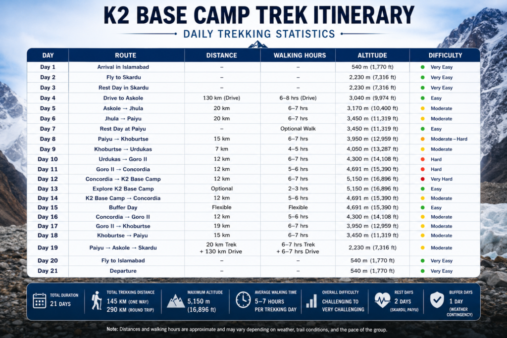
Daily Trekking Statistics
Understanding the daily trekking distances, walking hours, altitude gain, and difficulty level is an important part of planning your K2 Base Camp Trek Itinerary. While the trek does not require technical climbing skills, it demands consistent endurance over multiple days at high altitude. Some days involve gradual ascents on well-established trails, while others require walking across the rugged Baltoro Glacier and uneven moraine.
The table below provides a quick overview of each day, helping trekkers estimate the physical demands of the expedition and prepare accordingly.
Day
Route
Distance
Walking Hours
Altitude
Difficulty
Day 1
Arrival in Islamabad
—
—
540 m
Very Easy
Day 2
Fly to Skardu
—
—
2,230 m
Very Easy
Day 3
Rest Day in Skardu
—
—
2,230 m
Very Easy
Day 4
Drive to Askole
130 km (Drive)
6–8 hrs (Drive)
3,040 m
Easy
Day 5
Askole → Jhula
20 km
6–7 hrs
3,170 m
Moderate
Day 6
Jhula → Paiyu
20 km
6–7 hrs
3,450 m
Moderate
Day 7
Rest Day at Paiyu
—
Optional Walk
3,450 m
Easy
Day 8
Paiyu → Khoburtse
15km
6–7 hrs
3,950 m
Moderate–Hard
Day 9
Khoburtse → Urdukas
7km
4–5 hrs
4,050 m
Moderate
Day 10
Urdukas → Goro II
12km
6–7 hrs
4,300 m
Hard
Day 11
Goro II → Concordia
12km
5–6 hrs
4,691 m
Hard
Day 12
Concordia → K2 Base Camp
12km
6–7 hrs
5,150 m
Very Hard
Day 13
Explore K2 Base Camp
—
2–3 hrs
5,150 m
Easy
Day 14
K2 Base Camp → Concordia
12km
5–6 hrs
4,691 m
Moderate
Day 15
Buffer Day
—
Flexible
4,691 m
Easy
Day 16
Concordia → Goro II
12km
5–6 hrs
4,300 m
Moderate
Day 17
Goro II → Khoburtse
19km
6–7 hrs
3,950 m
Moderate
Day 18
Khoburtse → Paiyu
15km
6–7 hrs
3,450 m
Moderate
Day 19
Paiyu → Askole → Skardu
20 km Trek + 130 km Drive
6–7 hrs Trek + Drive
2,230 m
Moderate
Day 20
Fly to Islamabad
—
—
540 m
Very Easy
Day 21
Departure
—
—
540 m
Very Easy
Overall Trekking Statistics
Total Expedition Duration: 21 Days
Total Trekking Distance: Approximately 145 km (90 miles) one way and 290 km (180 miles) round trip
Maximum Altitude:5,150 m (16,896 ft) at K2 Base Camp
Average Walking Time:5–7 hours per trekking day
Longest Trekking Day: Askole to Jhula and Jhula to Paiyu (approximately 20 km)
Highest Camp: K2 Base Camp (5,150 m)
Rest Days: 2 (Skardu and Paiyu)
Buffer Days: 1 (Weather and flight contingency)
Overall Difficulty:Challenging to Very Challenging
k2-base-camp-trek-itinerary
This Daily Trekking Statistics table gives trekkers a clear overview of the entire K2 Base Camp Trek Itinerary, making it easier to understand the pace of the expedition, prepare for each stage of the journey, and plan their fitness and equipment accordingly. It also highlights why proper acclimatization and a well-structured itinerary are essential for a safe and successful trek to the base of the world’s second-highest mountain.
Highlights of Each Day
One of the reasons the K2 Base Camp Trek Itinerary is considered one of the world’s greatest trekking adventures is the incredible variety of landscapes and mountain scenery experienced throughout the journey. Every day introduces a new highlight, from lush valleys and dramatic granite towers to vast glaciers and the breathtaking views of K2 itself. Here are the unforgettable landmarks you’ll encounter along the route.
Baltoro Glacier
The Baltoro Glacier is the heart of the K2 Base Camp Trek Itinerary and one of the world’s longest non-polar glaciers, stretching for approximately 63 kilometers. Trekking across this massive river of ice is an unforgettable experience, with constantly changing landscapes of ice, rock, and moraine.
Walking on the glacier offers a true sense of wilderness, surrounded by towering mountains and some of the most famous climbing peaks on Earth. Every step across the Baltoro Glacier brings you closer to Concordia and ultimately K2 Base Camp, making it one of the most memorable sections of the trek.
Trango Towers
The Trango Towers are among the most famous granite peaks in the world and are internationally recognized for their nearly vertical rock faces. These spectacular towers first come into view near Paiyu and remain a constant companion during the early stages of the trek.
Their dramatic shape attracts elite climbers from around the globe, while trekkers enjoy some of the finest mountain photography opportunities anywhere in the Karakoram. Seeing the Trango Towers rise above the Baltoro Glacier is an experience that few people ever forget.
Cathedral Peaks
The Cathedral Peaks stand proudly beside the Baltoro Glacier and are named for their sharp, cathedral-like rock formations. These elegant granite spires create one of the most striking landscapes on the K2 Base Camp Trek Itinerary.
As the sunlight changes throughout the day, the peaks display different shades of grey, gold, and orange, making them a favorite subject for photographers. Their unique shape adds even more beauty to the already spectacular Karakoram scenery.
Masherbrum
At 7,821 meters, Masherbrum is one of the highest and most beautiful mountains in Pakistan. Its elegant pyramid-shaped summit dominates the skyline around Goro II and remains visible for much of the upper trek.
Often overlooked because of nearby 8,000-meter peaks, Masherbrum is considered by many mountaineers to be one of the most beautiful mountains in the Karakoram. Its snow-covered slopes create an unforgettable backdrop during the journey toward Concordia.
Muztagh Tower
Standing at 7,284 meters, Muztagh Tower is one of the most iconic peaks visible along the Baltoro Glacier. Its steep granite walls and isolated summit have made it legendary among climbers and photographers alike.
Although not as well known as K2 or Broad Peak, Muztagh Tower is often regarded as one of the most aesthetically perfect mountains in the world. It adds even more grandeur to the spectacular scenery of the Karakoram.
Gasherbrum IV
Gasherbrum IV rises to 7,925 meters and is famous for its magnificent west face, often described as one of the finest mountain walls on Earth. As you continue along the Baltoro Glacier, this impressive peak becomes increasingly prominent.
Its elegant pyramid shape and dramatic ridges make Gasherbrum IV one of the most photographed mountains during the K2 Base Camp Trek. Seeing it from Goro II and Concordia is one of the expedition’s unforgettable highlights.
Broad Peak
Broad Peak, the world’s twelfth-highest mountain at 8,051 meters, stands immediately beside K2 and is one of the first 8,000-meter peaks you’ll encounter near Concordia.
The route to K2 Base Camp passes directly by Broad Peak Base Camp, providing an excellent opportunity to observe climbing expeditions preparing for summit attempts during the climbing season. Its enormous size and broad summit ridge make it one of the defining landmarks of the expedition.
Concordia
Known as the “Throne Room of the Mountain Gods,” Concordia is widely considered the most spectacular campsite on the entire K2 Base Camp Trek Itinerary. Here, several major glaciers meet beneath a breathtaking collection of some of the world’s highest mountains.
From a single location, trekkers can enjoy panoramic views of K2, Broad Peak, Gasherbrum I, Gasherbrum II, Mitre Peak, Marble Peak, and many other towering summits. Very few places on Earth offer such an extraordinary concentration of giant mountains, making Concordia one of the greatest mountain viewpoints in the world.
K2
The ultimate highlight of the K2 Base Camp Trek Itinerary is standing beneath the mighty K2 (8,611 meters), the second-highest mountain on Earth. Unlike Everest, K2 remains wild, remote, and incredibly challenging, earning its reputation as one of the world’s most difficult mountains to climb.
Reaching K2 Base Camp is a lifelong dream for many trekkers. The sight of K2’s immense south face rising above the Godwin-Austen Glacier is both humbling and unforgettable. For many visitors, this single moment becomes the defining memory of their entire journey through the Karakoram.
Acclimatization During the Itinerary
Proper acclimatization is one of the most important factors in successfully completing the K2 Base Camp Trek Itinerary. As the trek gradually climbs from 3,040 meters in Askole to 5,150 meters at K2 Base Camp, oxygen levels decrease significantly, making it essential to allow the body enough time to adjust.
Our carefully planned itinerary includes gradual altitude gain, dedicated rest days, and well-spaced campsites to minimize the risk of altitude sickness and maximize the chances of a safe and enjoyable expedition.
Why Rest Day at Paiyu?
Paiyu is the final campsite before entering the challenging Baltoro Glacier and serves as the perfect location for an acclimatization day. Spending an extra day here allows your body to adapt naturally to the increasing altitude before continuing toward the higher camps.
The rest day also gives trekkers time to recover from the first few days of hiking, organize equipment, stay hydrated, and prepare for the demanding glacier section. This additional acclimatization greatly improves comfort and reduces the likelihood of developing altitude-related problems later in the trek.
Why Sleep at Concordia?
Concordia is located at approximately 4,691 meters (15,390 feet) and plays a vital role in the acclimatization process. Spending a night here before visiting K2 Base Camp allows your body to adjust gradually to the higher elevation instead of making a rapid ascent.
Sleeping at Concordia also provides extra time to enjoy one of the world’s most spectacular mountain amphitheaters while ensuring trekkers are better prepared for the final journey to K2 Base Camp the following day. This approach significantly increases both safety and overall trekking success.
AMS Prevention
Acute Mountain Sickness (AMS) is one of the primary challenges during any high-altitude expedition, but it can usually be prevented through proper acclimatization and responsible trekking practices.
To reduce the risk of AMS during the K2 Base Camp Trek, trekkers should:
Walk at a slow and steady pace without rushing.
Drink plenty of water throughout the day to stay hydrated.
Eat nutritious meals to maintain energy levels.
Follow the guide’s instructions regarding acclimatization.
Avoid alcohol and smoking at high altitude.
Report any symptoms such as headache, nausea, dizziness, or unusual fatigue immediately.
Descend to a lower altitude if symptoms become severe.
Our experienced local guides continuously monitor every participant’s health and ensure that the itinerary allows sufficient time for safe acclimatization. By following these precautions, most trekkers complete the K2 Base Camp Trek Itinerary safely while fully enjoying one of the world’s greatest mountain adventures.
Weather Throughout the Itinerary
The weather plays a major role in the success of your K2 Base Camp Trek Itinerary. Conditions change significantly as you gain altitude, and trekkers can experience warm sunshine during the day and freezing temperatures at night. Understanding what to expect at different stages of the trek helps you prepare the right clothing, equipment, and mindset for the journey.
Early Days
The first few days of the K2 Base Camp Trek Itinerary, from Islamabad to Paiyu, generally offer the most comfortable weather conditions. Daytime temperatures usually range between 15°C and 25°C (59°F–77°F) during the trekking season, while nights can drop to around 5°C to 10°C (41°F–50°F).
The trails are mostly dry, and the lower altitude makes hiking more comfortable. However, occasional rain showers are possible, especially in June and early July, so carrying a waterproof jacket is recommended.
Middle Days
As you continue from Paiyu across the Baltoro Glacier toward Urdukas and Goro II, the weather becomes noticeably colder. The glacier environment creates cooler temperatures throughout the day, and strong mountain winds are more common.
Daytime temperatures generally range between 5°C and 15°C (41°F–59°F), while nighttime temperatures often fall below freezing. Sunny mornings can quickly change into cloudy afternoons, so dressing in layers is essential throughout this section of the trek.
Higher Camps
The highest camps on the K2 Base Camp Trek Itinerary, including Goro II and Concordia, experience true alpine conditions. Oxygen levels are much lower, temperatures continue to decrease, and the weather can change rapidly without warning.
During the day, temperatures usually remain between 0°C and 10°C (32°F–50°F), while nights frequently drop to -10°C or even lower. Strong winds, snowfall, and freezing conditions are always possible, even during the peak trekking season. Warm clothing, insulated sleeping bags, gloves, and hats become essential at these elevations.
K2 Base Camp
Weather at K2 Base Camp is the coldest and most unpredictable of the entire expedition. Located at 5,150 meters (16,896 feet), the campsite experiences freezing temperatures throughout most of the season.
During the day, temperatures may rise to around 5°C (41°F) under clear skies, but nights often fall below -15°C (5°F). Snowfall, icy winds, and rapidly changing weather are common. Despite these harsh conditions, clear mornings often provide spectacular views of K2 and the surrounding peaks, making the challenging environment well worth the effort.
Tips for Following This Itinerary
Successfully completing the K2 Base Camp Trek Itinerary requires more than physical fitness. Careful pacing, proper hydration, suitable equipment, and respect for the mountains all contribute to a safe and enjoyable experience. The following tips will help you make the most of your expedition while reducing the risk of common trekking problems.
Walk Slowly
One of the biggest mistakes trekkers make is walking too fast during the first few days. At higher altitudes, your body needs time to adjust to lower oxygen levels, and rushing only increases fatigue and the risk of altitude sickness.
Maintain a slow and steady pace throughout the trek, especially after reaching the Baltoro Glacier. Remember, reaching K2 Base Camp safely is far more important than walking quickly.
Drink Water
Staying hydrated is essential throughout the K2 Base Camp Trek. The combination of high altitude, dry mountain air, and daily physical activity causes your body to lose fluids more quickly than usual.
Aim to drink at least 3 to 4 liters of water every day. Proper hydration helps improve acclimatization, maintains energy levels, and reduces the likelihood of headaches and altitude-related problems.
Layer Clothing
Weather conditions in the Karakoram can change within minutes, making layered clothing the most effective way to stay comfortable. Instead of wearing one heavy jacket, dress in multiple layers that can easily be added or removed throughout the day.
A typical layering system includes a moisture-wicking base layer, an insulating fleece or down jacket, and a waterproof outer shell. This approach allows you to adapt quickly to changing temperatures and weather conditions.
Use Trekking Poles
Trekking poles are one of the most useful pieces of equipment on the K2 Base Camp Trek Itinerary. They improve balance on uneven terrain, reduce pressure on your knees during descents, and provide extra stability while crossing rocky glacier sections.
Using trekking poles also helps conserve energy, allowing you to maintain a comfortable walking rhythm over long distances.
Sleep Well
Quality rest is essential during a high-altitude expedition. Although sleeping at higher elevations can sometimes be difficult, getting enough sleep helps your body recover from each day’s trek and prepares you for the next stage of the journey.
Try to stay warm, eat a nutritious dinner, remain hydrated, and avoid unnecessary physical activity before bedtime. Good sleep plays an important role in successful acclimatization.
Respect Altitude
Altitude should never be underestimated during the K2 Base Camp Trek. Even experienced hikers can develop symptoms of Acute Mountain Sickness (AMS) if they climb too quickly or ignore early warning signs.
Always listen to your guide, follow the planned itinerary, and report any symptoms such as headaches, dizziness, nausea, or unusual fatigue immediately. The carefully designed itinerary, including rest and acclimatization days, is intended to help your body adjust safely and maximize your chances of reaching K2 Base Camp successfully.
Frequently Asked Questions
1. How many days does the K2 Base Camp Trek take?
Our standard K2 Base Camp Trek Itinerary lasts 21 days, including arrival in Islamabad, travel to Skardu, acclimatization days, trekking to K2 Base Camp, a buffer day for weather delays, and the return journey. This carefully planned itinerary provides a safe pace for acclimatization and allows trekkers to fully enjoy the incredible scenery of the Karakoram.
2. Can the K2 Base Camp Trek itinerary be shortened?
Yes, some operators offer shorter 14 to 16-day itineraries. However, these schedules usually involve longer trekking days and less time for acclimatization. Our 21-day itinerary is designed to reduce the risk of altitude sickness while giving trekkers a more comfortable and enjoyable experience.
3. Why is there a rest day at Paiyu?
Paiyu is the final campsite before entering the Baltoro Glacier and serves as an ideal location for acclimatization. The rest day allows your body to adjust to the increasing altitude, recover from the first days of trekking, and prepare for the more demanding glacier section ahead. It is an important part of a safe and successful K2 Base Camp Trek Itinerary.
4. Is Concordia worth staying at?
Absolutely. Concordia is considered one of the most spectacular mountain campsites in the world. From a single location, you can enjoy breathtaking views of K2, Broad Peak, Gasherbrum I, Gasherbrum II, Mitre Peak, and several other towering summits. Spending a night here is one of the highlights of the entire trek.
5. What is the hardest day of the trek?
Most trekkers consider the journey from Concordia to K2 Base Camp to be the most challenging day. The high altitude, rocky glacier terrain, and thinner air require extra effort. However, reaching K2 Base Camp and standing beneath the world’s second-highest mountain makes every step worthwhile.
6. How far do you walk each day?
During the K2 Base Camp Trek, daily walking distances typically range between 7 and 20 kilometers, depending on the day’s route. Most trekking days involve 5 to 7 hours of walking, although some longer days may take slightly more time depending on trail conditions and the group’s pace.
7. Can beginners follow this itinerary?
Yes, beginners with excellent physical fitness, proper preparation, and a positive attitude can complete this itinerary. No technical climbing experience is required, but participants should train for several months before the trek and follow the guide’s instructions throughout the expedition.
8. Is the K2 Base Camp Trek itinerary safe?
Yes. When completed with experienced guides and a well-planned acclimatization schedule, the K2 Base Camp Trek is considered safe for physically fit trekkers. Our itinerary includes rest days, gradual altitude gain, experienced local guides, and a buffer day to help manage weather-related delays.
9. What happens if flights between Islamabad and Skardu are delayed?
Flights to and from Skardu are weather dependent. If flights are cancelled, the journey is completed by road via the Karakoram Highway. Our itinerary includes a dedicated buffer day to minimize the impact of unexpected weather delays and keep your expedition running smoothly.
10. Can I combine this itinerary with Gondogoro La Pass?
Yes. Many trekkers choose to extend their adventure by crossing the spectacular Gondogoro La Pass (5,585 m) after visiting K2 Base Camp. This option adds several days to the expedition and is considerably more challenging, requiring good weather, fixed ropes, and a higher level of fitness.
Ready to Experience the Ultimate K2 Base Camp Trek?
Standing beneath the mighty K2 (8,611 m) is a dream shared by trekkers from around the world, and our carefully designed 21-Day K2 Base Camp Trek Itinerary gives you the best opportunity to achieve it safely and comfortably. With gradual acclimatization, experienced local guides, and professional expedition support, you’ll enjoy one of the world’s greatest trekking adventures with confidence.
When you book your K2 Base Camp Trek with us, you’ll benefit from:
✔ Experienced local guides with extensive Karakoram expertise.
✔ Carefully planned 21-day itinerary for safe acclimatization.
✔ Small group departures for a more personal experience.
✔ High-quality camping equipment and professional logistics.
✔ All permits, transportation, and expedition management included.
✔ Transparent pricing with no hidden charges.
✔ Airport transfers and dedicated support from arrival to departure.
✔ Friendly team committed to your safety, comfort, and success.
Whether you’re planning your first high-altitude expedition or returning to the Karakoram for another unforgettable adventure, we’re here to help you every step of the way.